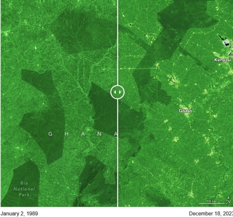
In southwestern Ghana, a patchwork of tropical forest lies among widespread farmland dotted with towns.
These forest fragments are remnants of the Upper Guinean forest of West Africa, a biodiversity hotspot that has been diminished by human activity and fires.
Primates, elephants, hippopotamuses, and butterflies are among the thousands of animals that live in the region’s primary forests, which are almost entirely within a network of forest reserves.
But satellite images indicate that these protected forest remnants have become even smaller in recent decades.
The false-color images above, acquired by the Landsat 4 and Landsat 9 satellites, show 12 protected forest reserves and Bia National Park in the Bia-Goaso forest district in 1989 (left) and 2023 (right).
The forested canopies of the reserves are dark green, whereas the surrounding landscape is lighter green.
“This area has historically been important forest habitat for biodiversity, but elephant populations have declined precipitously because of human encroachment and habitat degradation,” said Michael Wimberly, a professor of geography and environmental sustainability at the University of Oklahoma.
The photograph below, taken by Wimberly, shows intact forests in a reserve east of the Bia-Goaso region.
Photograph of tall green trees in the Bobiri forest reserve in Ghana, taken from the ground by Michael Wimberly. In the distance, a group of people are walking along a trail in the forest.

Wimberly and a team of researchers in the United States and Ghana used Landsat data to study forest degradation, loss, and recovery in the reserves across Ghana from 2003 to 2019.
Although vegetation change was relatively slow from 2003 to 2015, it picked up significantly between 2015 and 2019. Overall, there was more forest loss and degradation than recovery, resulting in a gradual decline of tree cover.
The drivers of change here are multifaceted, noted Wimberly. In 2016, drought associated with El Niño parched forests and promoted fires across more than 12 percent of Ghana’s moist semi-deciduous and upland evergreen forests.
Forest loss was especially prevalent in a reserve known as Bonsam Bepo, south of the city of Goaso.
In a reserve southeast of this image, mining operations contributed to forest loss. In the reserve north of Bia National Forest, widespread logging for timber from 2017 to 2019 led to forest degradation.
In other reserves, such as Krokosua (the u-shaped reserve at the bottom of the image), the expansion of cocoa farms has consumed forest. Ghana and neighboring Côte D’Ivoire produce about two-thirds of the world’s cocoa.
A 2024 United Nations report on the state of the world’s forests highlighted the Forest Data Partnership, an effort to help people in Ghana access remote sensing data to track commodities linked to deforestation and prevent forest loss.
The approach is being field-tested in Ghana and at the joint NASA-USAID SERVIR program’s regional hub for West Africa to help make agricultural production and food systems more sustainable.
Wimberly and colleagues continue to monitor Ghana’s tropical forest landscapes and forest reserves using Landsat data and models to classify the health of forests.
Their updated results can be explored in this interactive map.
NASA Earth Observatory images by Michala Garrison, using Landsat data from the U.S. Geological Survey. Photograph of the Bobiri forest reserve in Ghana by Michael Wimberly. Story by Emily Cassidy.
ALSO READ:


